-
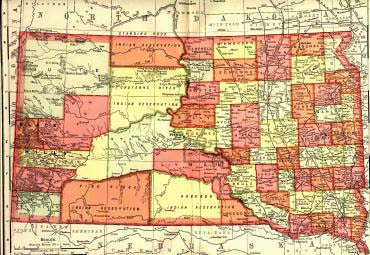
South Dakota in 1908
~from The New International Encyclopædia, Vol. XIV, Daniel Coit Gilman, Editor (New York: Dodd, Mead & Co., 1908). Courtesy of Danny Brown. (665 KB)
-
- County Boundary Maps - courtesy of Gold Bug Historic Maps & Software
- Topographical Map (233 KB)
- Topographical
Map with County Boundaries (246 KB)
- Go to the US Geological Survey's Geonames web site.
- In the box labeled "Feature Name", enter the name of the place you are looking for.
- Use the state pull-down menu to choose the state.
- You can limit your search by using the other boxes for the county name and/or feature type.
- If the search turns up the location, you can then click on the feature's link to get more information. On the right hand side of the page is a list of mapping sites that will show the location of the feature.
Online Maps
| The following maps of South Dakota and Dakota Territory are online and available for download. Please note the size of the map before downloading—for those of you with slower connections it may take several minutes to download the larger maps. |
Maps of South Dakota
Here's how to find out where a geographic name (town, church, cemetery, creek, lake, or anything else that appears on a USGS map of the region) is located in SD (or anywhere else in the US):
|
Get a free SD State Map
The State Department of Tourism will send you a large map (45"x 18") - all you need to do is ask.
-
South Dakota Department of Tourism
711 East Wells Avenue
Pierre, South Dakota 57501-3369
Telephone: (800) 732-5682
Fax: (605) 773-3256
How to Order County Maps
County Maps of South Dakota which show cemeteries, churches, and usually
include the township and range numbers can be purchased from the State Department of Transportation Check out their web site for prices and ordering information. |
Return to SDGENWEB
Return to SDGENWEB Archives
Return to USGenWeb
This page was last updated 18 Dec 2021 & 14 Sep 2024
